The mighty Fitzroy River in Queensland, Australia, boosts a large and complex catchment area. It can carry huge volumes of runoff to the sea from one or more of its many watershed areas as a result of heavy rainfall events.
The extraordinary volumes tend to result from cyclone disturbances that form rain depressions, for example the 1991 Fitzroy flood event in the aftermath of cyclone Joy and the 1918 flood associated with a cyclone that hit Mackay on January 20 that year.
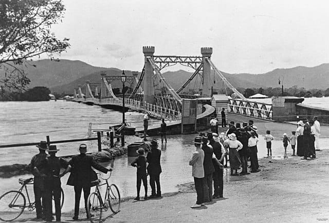
The flooded waters pass through Rockhampton in the lower reaches and on out into Keppel Bay at the coast affecting the Capricorn Coast beaches and out into the Great Barrier Reef lagoon. During these times, an abrupt change in colour delineating the fresh flows from the seawater can be seen in the Keppel Bay.
Historic flood events
The Fitzroy Basin has experienced several major flood events throughout its history.
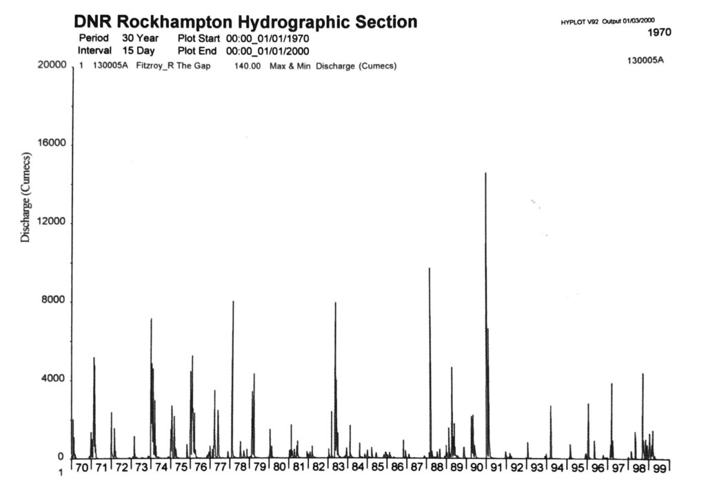
Climate in this area is highly variable and the occurrence of flood events is highly irregular. Not only do these occurrences differ between years but also between decades. A good example can be seen by comparing flows at The Gap during the 1970s with those during the 1990s.
The chart also shows the 1991 flood event.
Some of the significant flood events that have impacted the Fitzroy River and surrounding areas, apart from the 1991 event, include the 1918 flood, the 1954 flood, and the 2008, 2011 and 2013 flood events.
The 1918 flood is one of the most severe flood events recorded in the region, with devastating impacts on homes, infrastructure, and agriculture.
The 1954 flood also caused widespread damage and disruption, leading to significant economic losses.
The 2008 flooding event was widespread. Most catastrophic was the overflow of the Fairbairn Dam resulting in downstream flooding in Emerald with 2,700 residents needing evacuation.
The 2010–2011 flood was another catastrophic event that affected thousands of residents and businesses, leading to extensive flooding and evacuations. It was far worse for Emerald. Known as the “Flood of Record” for Fairbairn Dam it resulted in inundation of 95% of homes in Emerald when the Nogoa River broke it’s banks and rose to a peak of 16.05 m on 31 December 2010.
In 2013, the region experienced another major flood event that tested the resilience of the community and infrastructure in the area. The Callide dam in the lower Dawson experienced a “flood of record”.
A history of flooding – the mighty Fitzroy River, Queensland
Many will know of the recent flooding of the Fitzroy River, possibly going back as far as 1918. But maybe not the mighty floods prior since records started in 1859. The following is a list of Fitzroy River floods compiled from newspaper reports of the day.
| Year | Reports |
|---|---|
| 1860 | Continuous heavy rains shuts down postal communication; Fitzroy River at Canoona crossing rises 40′ (12.2 m) – reported in Ipswich newspaper 17 March 1860 |
| 1862 | Nogoa, Mackenzie, Comet, Isaacs and Connor rivers have risen. Whole of country between Rannes and Dee River flooded. Water at Rannes rose up to 40′ (12.2m). Unprecedented flood recorded in Fitzroy River at Yaamba, 6′ within level of township – reported in Ballarat’s The Star newspaper 7 May 1862 from Rockhampton Correspondent |
| 1864 | River at Rockhampton attains height of 13.53′ (4.12 m) above the Fitzroy Street wharf on 18 March 1864 – reported in Rockhampton newspaper 19 March 1864 |
| 1875 | Heavy rain started 23 February 1875; Fitzroy River rose to 1864 levels; lower portion of Rockhampton and all back country floods; Dawson and Mackenzie river levels unprecedented with the Dawson Bridge a full 16′ (5 m) under water – R’ton corres., Mackay newspaper 12 March 1875; 20-30 head of cattle of Birkbecks, Glenmore, are carried in floodwaters down the Fitzroy river bellowing as they passed Lake’s Creek – Grafton newspaper 30 March 1875; No Rockhampton bridge at this time. |
| 1877 | Dawson River flooded and now uncrossable – Bulletin 9 Jun 1877 |
| 1878 | Fitzroy River higher than at any time since 1875 – The Queenslander 9 March 1878 Heavy rain floods Dawson, Comet, Nogoa, Mackenzie and Fitzroy Rivers – Morning Bulletin 28 Feb 1878 |
| 1879 | January reports of fresh in the Fitzroy River at Rockhampton, nearly level with the wharves – Sydney newspaper 11 January 1879 |
| 1880 | March reports of Dawson, Nogoa and Comet River high flows and river at Rockhampton rises to 6′ (2 m) over wharves; Dawson River rises to within a few feet of the railway bridge – Morning Bulletin 25 March 1880 |
| 1881 | April reports of ‘full flood’ at Rockhampton with wharves under water up to 5′ (1.5 m) and 2 ferry houses washed away. |
| 1890 | Recorded flood mark at Rockhampton 27′ 11″ (8.5 m) |
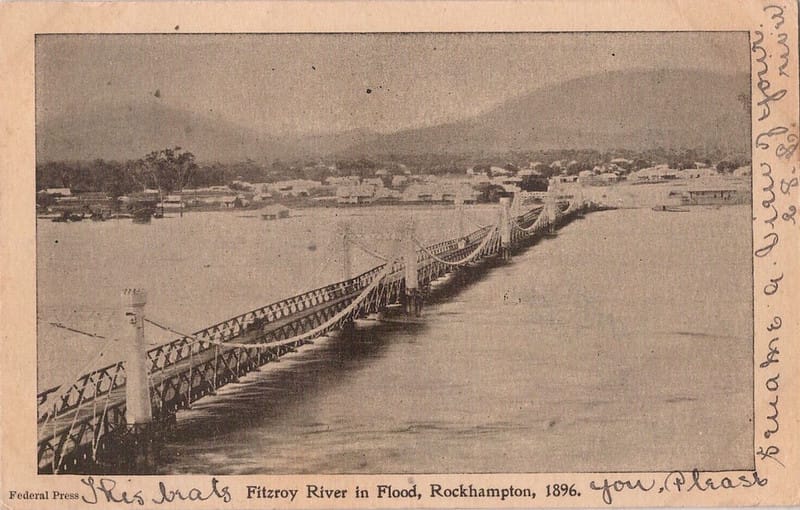
| 1896 | New record flood mark at Rockhampton 29′ 2.5″ (8.9 m) – Daily Mercury 18 February 1954 Body of man drowned in flood found on an Emu Park beach – The Telegraph 17 February 1896 |
| 1910 | Reports of two floods: January and March. Torrential rain March – Newcastle newspaper 21 March 1910 *Highest flood level at Rockhampton in 12 years, though “not a really big flood” – Morning Bulletin 30 March 1910 Gauge at Rockhampton 25′ 7″ (8.4 m) – The Capricornian 2 April 1910 |
| 1917 | January report of Fitzroy River at Rockhampton gauge height of 20’6″ (6.2 m) – Brisbane Courier 13 Jan 1917 Clermont flooded – The Capricornian 20 January 1917 |
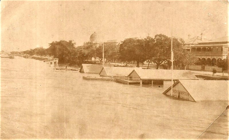
| 1918 | New flood record mark at Rockhampton of 10.11 m (flood gauge 8.65 m AHD) according to Rockhampton Regional Council records. Heavy rainfall following cyclone that hit Mackay. |
| 1928 | April reports of “Tropical Disturbance” (MB) and Rockhampton flooding, river level 27′ (8 m) – Evening News 28 April 1928; Drowning fatality of elderly man from Frenchman’s Creek Rockhampton – Toowoomba newspaper 23 April 1928; Serious flooding in the Dawson. Seven lives lost at Konara Siding below Mt Morgan – Daily Standard (Brisbane) 25 April 1928 |
| 1940 | March gauge at Rockhampton showed river level at 25′ (7.6 m) – Evening News 28 March 1940 |
| 1950 | December report of river height at Rockhampton 18′ 11.5″ (6 m) – Morning Bulletin 8 December 1950 |
| 1951 | January report of 1000s of acres covered by up to 8′ (2.5 m) of water; Riversleigh gauge peaked at 78′ 9″ (24 m) Dawsonn at Boolburra 47′ 9″; – Warwick Daily News 20 January 1951 |
| 1954 | February report of 2nd highest flood record at Rockhampton of 9.4 m (flood gauge 7.95 m AHD), according to Rockhampton Regional Council records |
| 1991 | January 12 report of 3rd highest flood record of 9.3 m (flood gauge 7.85 m AHD), 2nd peak in the flood event. |
| 2008 | River height peak at Rockhampton 7.5 m; Nogoa at Emerald 15.37 m, 2nd largest flood on record. |
| 2011 | Fourth highest flood record at Rockhampton with January peak of 9.2 m; Largest floods on record for Emerald, Rolleston and Theodore |
| 2013 | Peak of 8.61 m at Rockhampton flood gauge |
| 2017 | Peak of 8.9 m at Rockhampton flood gauge |